services
By design, we craft bold, meaningful, strategy-based services that will empower clients with confidence that will connect with their target goals.

Aerial Photo + Videography & RealityCapture Specialist
We are FAA-approved and Part 107 certified since 2021. Our drone services include high-quality images and videos for real estate properties (commercial & residential), structure inspections, video productions for social/news media, and survey mapping imagery. From a simple roof inspection to the Metaverse, we will translate your idea into gorgeous, impactful, and shareable data with just a click!
capabilities

___
Photo + Videography
Corporate/estate properties with aerial photo/videography are enormously powerful tools for showcasing your business, location, and process to your audience...

___
Audit/Inspections
Roofers are quickly looking up to aerial inspection solutions to help them get the fastest and most reliable data fast. Any Infrastructure & construction projects...

___
Aerial Oblique/Ortho-Mappings
We have created several aerial mappings for dozens of clients. We can provide you with detailed drone photo imaging that maps out hundreds of acres at a high resolution...

___
Video/Photogrammetry 3D
Now we can capture real-world assets and bring them into digital reality by using photos-to-point cloud coordinates that will take your physical project site into a virtual 3D model...

___
Aerial 360/180 Panoramic
360 drone photos/videos engage and excite customers, bringing them to places they could never access on their own. We use 180 aerial footage to create panorama visions...

___
Aerial RTK Survey Imagery
We are one of the few sUAV operators to offer this imaging service for surveyors. Capturing aerial footage of land and construction zones requires a unique set of skills...
___
Photo + Videography
Corporate video production and aerial drone photography are enormously powerful tools for showcasing your business, your location, and your process to your customers. And, of course, aerial drone photography is increasingly used in digital production. We strive to get just the right shot each time. We listen carefully and always hold ourselves to the highest performance standards.
Aerial footage reel of recent projects for various clients below.

___
Aerial Oblique/Ortho-Mappings
Civil works, infrastructure projects and construction sites, etc. These types of projects can benefit enormously from professional remote pilots. We are one of the few drone specialists to offer this type of service as a data collection provider. Capturing aerial footage of cropland, landscapes and construction zones requires a unique set of skills to get the result you need to make the best decision in the field.
We have created several aerial mappings/topos for dozens of clients. We can provide you with detailed drone photography that maps out hundreds of acres at a high resolution, ready to send in an instant to engineers, land surveyors, construction companies, and more.
This aerial ortho-mapping of a new house development: A Drive by side project, it took about five minutes of flight time to create this 26 acre land site (491 photos to create this 2.5D orthographic models). Once again, the importance of site monitoring in construction industry can’t be overstated. From managing resident housing developments, commercial construction to infrasucture, progress monitoring ensures your projects stay on time and within your budget as well… Especially dealing with underground utilities.
Better Quality: click on the cog settings icon and set to HD quality.
Camera Orbit Off-Track: click on help (?) icon and touch RESET CAMERA VIEW.
Better Quality: click on the cog settings icon and set to HD quality.
Camera Orbit Off-Track: click on help (?) icon and touch RESET CAMERA VIEW.

___
Aerial 360/180 Panoramic
360 drone videos engage and excite customers, bringing them to places they could never access on their own. We use 360 aerial drone photography and videography to create panoramic images that offer viewers access to untapped worlds, both real and imagined. We use camera technologies to create:
• 360 Video/Photo Documentations of your onsite facilities
• 360 Panorama Presentations
• AR/VR Experiences
We use 360° panos to show the actual progress and how it reduce costs on your next construction project. Photo/Video documentations is a great way to show the overall progress from initiation to completion (the good, bad & soluble challenges). The importance of site monitoring in construction industry can’t be overstated. Progress monitoring ensures your projects stay on time and on budget!
Navigation: select playhead and drag/click to your desirable location on the timline.
Better Quality: click on the cog settings icon and set to HD quality.
Camera Orbit Off-Track: click on help (?) icon and touch RESET CAMERA VIEW.
Navigation: select playhead and drag/click to your desirable location on the timline.
Better Quality: click on the cog settings icon and set to HD quality.
Camera Orbit Off-Track: click on help (?) icon and touch RESET CAMERA VIEW.
___
Audit/Inspections
Roofers are quickly looking up to aerial survey drone solutions to help them get the fastest and most reliable data. The whole process could take days to coordinate, especially in the case of inclement weather. Besides, roofers could be exposed to brutal weather conditions, both hot and cold. A drone inspection with high-resolution imaging takes a fraction of the time and can be done in almost any weather.
• Roofs
• Telecom Towers
• Energy & Utilities
• Infrastructure Projects
• Progress Monitoring
• Stockpile/Data Assessment
___
Video/Photogrammetry 3D
RealityCapture/Scan: Now we can capture real-world assets and bring them into digital reality by using photos-to-point cloud coordinates that will take your physical site project to a virtual 3D model (digital twin) in less than an hour. More convenient and cost-efficient than ever.
Texas African American History Memorial is an outdoor monument commemorating the impact of African Americans in Texas, installed on the Texas State Capitol grounds in Austin, TX. The memorial was sculpted by Ed Dwight Jr. and erected by the Texas African American History Memorial Foundation in 2016. It took about a hour of flight time to create this life-size monument on-site (650 surrounding photos to create this digital 3D model).
Better Quality: click on the cog settings icon and set to HD quality.
Camera Orbit Off-Track: click on help (?) icon and touch RESET CAMERA VIEW.
English-sytle stone arch bridge over a pond on Festival Drive in the Blount Cultural Park, which is reminiscent of an English countryside… This 250-acre park is home to the Montgomery Museum of Fine Arts, etc. The park features ponds, miles of walking trails, a natural amphitheater and picturesque scenery. It took about a hour of flight time to create this life-size bridge on-site (828 surrounding photos to create this digital 3D model).
Better Quality: click on the cog settings icon and set to HD quality.
Camera Orbit Off-Track: click on help (?) icon and touch RESET CAMERA VIEW.
___
Aerial RTK Survey Imagery
Civil works, infrastructure, visual/thermal inspections, land development, and construction sites, etc. These types of projects can benefit enormously from the expertise of professional UAS remote pilots. We are one of the few data capture specialists to offer this imagery service for surveyors. Capturing aerial footage of cropland, land development, and construction zones requires a unique set of skills, including a thorough understanding of the regulations and laws applicable to each state/area where we're working.
Here is an example of 995 camera inputs that made this dataset an orthographic landscape of possibilities.
AERIAL SURVEY IMAGERY DISCLAIMER: We have the capability of aerial data collection, but we do not interpret our aerial mapping imagery as a survey-grade dataset. For projects where exact measurements are required, we need to rely on a licensed land surveyor or survey engineer on these missions. We can assist in efficiently gathering this information under the direction of a licensed land surveyor, etc. The information delivered by KWARE DESIGN isn't supposed to be a survey. Although a surveyor could verify and certify the information delivered. HIRED A LICENSED SURVEYOR WHO HAS A CREW SET CONTROL ON THE PROJECT, WE CAN COLLECT YOUR DATA.
Many surveyors we work with have the ability to process drone data in-house. We also offers per project pricing with no commitment or contract. We are here as an options when your bandwidth is tap.
Planimetric features are visible from a birdeyes view, like clean topographic data with spot elevation points, breaklines, 1’ contours, and a digital surface model. We will mark all visible features such as paint striping, utility access, edge of pavement/curblines, building footprint/driplines and more. Connect with our online data plateform with your projects, and gives your clients what they’ve always wanted: fast and predictable turnaround times. Get your deliverables when you need them.
Drone roof inspections take minutes to complete and can be reviewed much sooner than somone can walk over the rooftop. We may find that thermal inspection is a great starting point for initial preconstruction assessment on tenant improvement or renovation projects. Here is a snapshot of thermal anomalies to review the markup annotations to share with your parties involved at anytime or anywhere. This example report will generate annotated thermal imagery, temperature data, facilitating efficient communication and issue tracking.
We're the best at what we do!
PROFESSIONAL
From real estate photos to digital media, we approach every project with the utmost level of professionalism. Years of experience have earned our trust among colleagues.
CLIENT-CENTERED
Our clients deserve the best! With every project we produced, we always work to ensure that our client loves the end result.
QUALITY & TRUSTED
From a simple flyover to the most advanced automated systems - we use only the best equipment and technology. You’ll see the difference in your footage.

Ken is an excellent communicator and would even remind us when project deadlines were approaching or if reviews and feedback were pending. Ken is quick to execute projects and always sticks to the agreed-upon schedules. We never had to worry, Ken is always on top of it. When projects were delivered, he would seek feedback and be very accommodating about new change requests. Ken is certainly a key contributor to the professionalism of our operation.
Shaina W.
Radiant Vision Systems
Seattle, WA
Amazing, solid partnership! Extremely responsive, professional, and just flat-out capable! Our experience was outstanding! We will continue our venture to the next assignment!
Ray L.
Bees360
Houston, TX
Ken is amazing to work with! He has been working with us to film our new ad campaign on the go as it travels throughout the city. The video quality is fantastic and he is able to capture our vision perfectly on screen.
Sallie M.
Movia Media
Austin, TX
Ken has been fantastic from the beginning to the end. We have appreciated the professionalism and expertise Ken provides throughout the process of our construction business.
John K.
Provident GC
Dallas, TX
UASSIST is an enhanced data collection specialist (drone tech-as-a-service) powered by AI from several SaaS platform partners. Equipped with advanced sensors and cameras, our UAV can capture high-resolution images and videos, enabling researchers to analyze the data in greater detail. Moreover, our specialists can program specific flight paths/plans and capture data at predetermined intervals, ensuring that the data is consistent and reliable throughtout the process. Using our UAV is an advantage for data collection is our ability to cover large areas in a relatively short amount of time. This method can quickly fly over large fields in the industry, capturing images and data that can be used to identify areas of concern and inform decision-making. This not only saves time but also helps to optimize resources and improve overall efficiency.
The most significant advantages of using our aerial service for data collection is our ability to access hard-to-reach locations. Flying over rugged terrain, dense forests, new land developments and bodies of water, allowing researchers to gather data from areas that would be difficult or impossible to reach on foot. This not only saves time and resources, but also ensures that the data collected is more comprehensive and accurate. That is why it's important to have some of the best technologic partners in our corner to work with during a mission/project like yours... CAPTURE, PROCESS & SHOW DATA-DRIVEN RESULTS!
___
Technology Partners
Innovative minds share a common goal, resolving complex problem through creative ways of thinking. Our partners provide us long-term guidance and support that supplements our in-house technology expertise. We thrive with them, become part of their progress, and do everything possible to continue producing great projects together with awesome results for our clients. Here are a few who have chosen to work with us during this adventure.
___
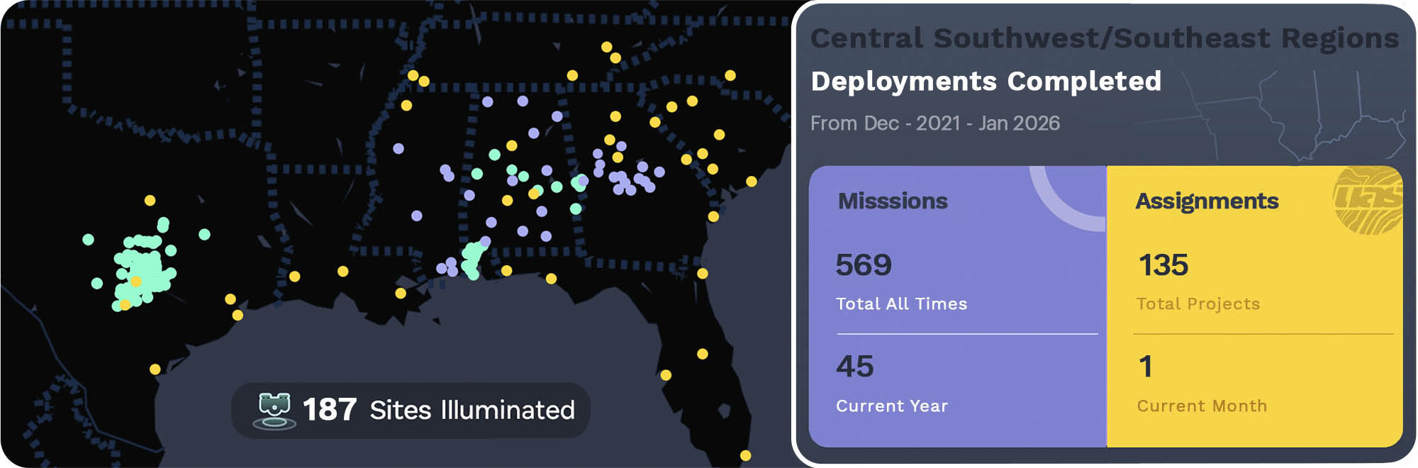
FAA Regulated & Certified Drone Service Provider
KWARE DESIGN is FAA-approved, Part 107 certified, and fully insured. Legal sUAV/UAS operation based in Central Texas region of the US - with the approval to take videos and photography anywhere in the USA, day or night. We have flown over several flight plan missions and counting. We are fully covered for $2M commercial aviation liability insurance provided by SkyWatch. FAA Part 107 certified, day/night waiver in Class B,C,D,E airspace statewide. Our operation is FAA-registered remote pilots.
Our agency provides high-quality aerial photo/videography, audit/inspection, mapping, and reality capture services customized to your needs. Our clients have us flying missions several times a week all over southern states.
Certs, legal, safe & ready to fly
- FAA Approved P107 UAS Recurrent, Night Operations §107.29, Visual Observer §107.33
- FAA Flying Over People & Moving Vehicles Waivers Approved (ref# 107W-2024-04751)
- FEMA - Incident Command System: 100 & 200 Certified
- OSHA 10 & Radio Frequency Safety Certified
- Drone Deploy Pilot & Construction Analyst Certified
- Pre/Post-Flight Preparations & Checklists
- Risk Management & Site Survey Procedures
- Weather, Airspace & Airport Proximity Awareness
- Authorizations to Fly within Class B, C, D and E airspace
- Aircraft Maintain, Documented & Registrated
- LAANC & FAA DroneZone Ready for Restriction Airspace
- UAV Liability Insurance Coverage for $2M
Flexible Pay-As-You-Go Price Options
___
Pricing is quote-based for each individual project.
If you haven't contracted a drone specialist before you might assume it's because of the cost. This might not be the case with us. We've listed some sample price packages below to help change your mind. Nothing is set in stone, and we can provide more accurate estimates once we learn more about your requirements for your project.
You can choose combinations of add-on services that are endless. Give us fifteen minutes to learn about your project and we can provide you with a customized estimate. We can create quotes for each project based on that individual project’s size, complexity, and the deliverables requested. Our pricing is extremely competitive, offering up to 70% cost savings over traditional methods. We will take great personal care in every order we fulfill. Coupled with the latest technology with our creative team, we can bring your next project to life and show the value you and your customers deserve.
We aim to ensure every step is as smooth and straightforward during your project as possible. From aerial photography to video of a luxury high-end real estate property; UASSIST can serve you effectively!
NOTICE: Authorization might be required due to FAA airspace restrictions within your project area. Be advised, the weather could also affect scheduling. All pricing and offers are subject to change due to the economic forecast. Travel fees could apply, please see below.
Aerial photo +
Videography
Basic Aerial Imagery
Image capture,
digital delivery
(18 photos + 1 orbit viz)
$195
Aerial Oblique/
Ortho-Mappings
2D/3D Map Dataset
Pricing for image
capture and process
hourly rate
(depends on project)
Aerial
panoramic
Basic Aerial Footage
image/video capture,
digital delivery
(3 maximum)
$155
Aerial
Inspections
Basic Aerial Imagery
Image capture,
digital delivery
(36 photos + 2 orbit viz)
$325
Aerial
Reality Capture
3D Model/Asset
Pricing for dataset
capture & process
hourly rate
(depends on project)
Aerial RTK
Survey Imagery
Imagery/Dataset
Pricing for capture,
digital delivery
hourly rate
(depends on project)
* Pricing varies by the size of your project. Additional travel fees may apply if outside threshold of 60 miles (0.75¢ per mile).
Let's Discuss it!
___
Are you juggling more than you can handle? In these stressful times, we can take some of the work off of your hands, so that you can focus on what's important. We can discuss how we can provide you with the options that best fit your business needs.
How much do your services cost?
____
Answer: The cost of each service varies based on certain factors, which drone/s is required, mission location, date/time, and deliverable data/content for your project. How many pilots are needed? Once you contact us, we have the necessary info, then we can quote your project with a competitive package deal. Consultation is free and there is no obligation or relentless sales hook. We look forward to hearing from you!
what pay methods DO YOU ACCEPT as payment?
____
Answer: You will receive an invoice from us when the shoot is complete. You can pay either by corporate direct deposit or online payment platforms like Stripe or Cash app (transaction fees/rates may apply).
If paid by check, must be paid at the time or before an appointment session. Please mail check to this address: KWARE DESIGN, LLC. PO BOX 242052, MGM, AL 36124
